Sale on canvas prints! Use code ABCXYZ at checkout for a special discount!

Boundary: Bleed area may not be visible.


by Vincent Monozlay
$47.99
Size
Orientation
Material
Image Size
Product Details
Our luxuriously soft blankets are available in two different sizes and feature incredible artwork on the top surface. The bottom surface is white. Our 100% polyester blankets are available in two different styles: plush fleece and sherpa fleece. Plush fleece blankets are soft and fluffy on both sides, whereas sherpa blankets are smooth like a soft sweater on the artwork side (i.e. shorter threads) which provides for a sharper image. Looking for a recommendation? Go with a 60" x 80" plush fleece blanket. It's soft and luxurious on both sides... the artwork looks incredible... and the size is just right for everyone.
Design Details
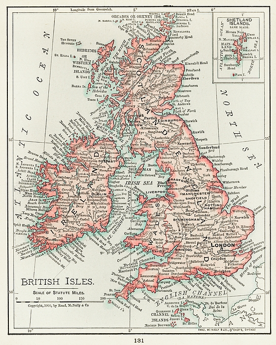
Universal Atlas of the World, A cartographic map of the British Isles. published in 1900.
Care Instructions
Machine wash cold and tumble dry with low heat.
Ships Within
1 - 2 business days

Painting

Canvas Print

Framed Print

Art Print

Poster

Metal Print

Acrylic Print

Wood Print

Greeting Card

iPhone Case

Throw Pillow

Duvet Cover

Shower Curtain

Tote Bag

Round Beach Towel

Zip Pouch

Beach Towel

Weekender Tote Bag

Portable Battery Charger

Bath Towel

Apparel

Coffee Mug

Yoga Mat

Spiral Notebook

Fleece Blanket
Universal Atlas of the World, A cartographic map of the British Isles. published in 1900.
In 1968, I was born in Nitra, Czechoslovakia (now Slovakia). My father, an amateur photographer, was the inspiration for my interest in photography and art. I enjoy photography, HDR photography, restoring and colouring old photos, portraits, photo art, AI art and old masters.
$47.99


There are no comments for A cartographic map of the British Isles. published in 1900. Click here to post the first comment.